
Keyword
Visual Counts/Observations
38 record(s)
Type of resources
Topics
Keywords
Contact for the resource
Provided by
Formats
Update frequencies
Status
draft
-
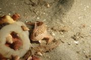
Distribution and size frequency patterns of sessile organisms such as sponges may vary among and within neighbouring reefs. In this study, we examine small scale variation of dictyoceratid sponges (class Demospongiae), commonly found on coral reefs, by surveying six neighbouring islands in central Torres Strait. Each island had four study sites, at least 1 km apart, with each site consisting of three shallow (4-6 m) and three deep (10-15 m) 20 m2 transects. For each transect, we recorded the number of each species and measured the size of the more common dictyoceratid sponges. Seven species of dictyoceratid were recorded in central Torres Strait, with only three species, Coscinoderma sp., Dysidea herbacea and Hyrtios erecta, common to all six islands. Abundance patterns generally varied greatly among islands or sites within islands, perhaps resulting from a combination of physical, biological and stochastic factors. More dictyoceratids were found in deeper water, although abundance across depth for some species varied among islands or sites. Size frequency distribution patterns also varied greatly among islands and between dictyoceratid species, indicating that factors that may promote growth for one species may not necessarily promote growth for a related species. This study shows that patterns of abundance and size of dictyoceratids can vary greatly over small spatial scales and that patterns are species specific.
-
Dive surveys were conducted in 2015 and 2016 to establish a baseline and monitor the status of the critically endangered spotted handfish (Brachionichthys hirsutus) population. This dataset contains track records of variable length, GPS tracked underwater visual census transects conducted within 11 sites across the Derwent Estuary (n=9) and D'Entrecasteaux Channel (n=2). Records illustrated search effort (transect length, swathed area) and total fish sighted along each transect. Data were also presented in a standardised unit, with density estimates (fish per hectare [Ha]) extrapolated for each transect. In addition, this dataset also included information for each sighting of individual fish. This dataset contains size measurement (total length) and location (depth, latitude, longitude) records for each sighted fish.
-
The marine benthic habitats of seabed areas between the reefs of Torres Strait were classified with data collected on epibenthos abundance, seagrass presence or absence, substrate type and water depth from 1984 to 1989 at 984 sites in an 12,347 square km study area in central Torres Strait. An idex of habitat diversity, calculated as the variety of distinct habitats within a 10 x 10 km window passed over the study area indicated that the areas with highest diversity of habitats were among the reefs and islands that formed two bands; one from Cape York to Buru Island, and the other from Cape York to Daru Island that included the Warrior reef complex. Refer to the compiled report: Long BG and Taranto TJ. (1997) Habitat Classification Of Seabed Areas Of Torres Strait, Northern Australia. CSIRO Division of Marine Research, QLD, Australia.
-
Spatial variability in community structure of dictyoceratid sponges (Class Demospongiae; Order Dictyoceratida) was examined on coral reefs in Torres Strait, an archipelago of islands and reefs between northern Queensland, Australia, and Papua New Guinea. Dictyoceratid sponge abundances and environmental parameters were recorded at 4 locations, separated by 50-220 km. Each location was subdivided into 5-7 sites, each ≥2 km apart. At each site four 50x2 m belt transects were quantitatively surveyed, recording dictyoceratid numbers, substrate type (rock, rubble and sand), water clarity, degree of reef slope and depth. Dictyoceratid abundance was similar among locations, averaging 15.5 individuals per 100 m2, but varied significantly among sites. Twenty three dictyoceratid species were recorded in Torres Strait, with approximately half (12/23) found in only one location. Canonical Correspondence Analysis determined that the measured environmental factors explained only 26% of the spatial variation. Cluster analysis revealed a complex dictyoceratid community structure with consistent patterns among neighbouring sites and among sites separated by hundreds of kilometres. Conversely the dictyoceratid community could vary greatly between neighbouring sites 2 km apart and on the same reef complex. The results of this study suggest that spatial variability of dictyoceratid sponges in Torres Strait is influenced by a combination of environmental, biological and stochastic processes.
-
Total zooplankton biomass (g dry weight) were recorded from stepped oblique bottom to surface plankton tows, using a 140-142 micron net. The data also includes a corrected biomass value, allowing comparisons to be made with later data collected using a 250 micron net size. Data were collected during nine cruises that took place between 1975 and 1977 on chartered boats and the "Kalinda". Related datasets include the counts of prawn larvae from these tows.
-
This series of twelve, monthly, fish-spotting maps has been prepared from logs of CSIRO fish spotting aircraft, the New South Wales State fisheries aircraft and the Fish Protein Concentrate aircraft based in Tasmania. The CSIRO fish-spotting aircraft was funded by the Fisheries Development Trust Fund.
-
The biomass and species composition of tropical zooplankton in Albatross Bay, Gulf of Carpentaria, northern Australia, were examined monthly for three years between March 1986 and March 1988. Zooplankton taxonomic groups were identified to species level where possible, with a primary focus on copepods. Abundance data are assumed to be numbers per cubic metre, but this has yet to be confirmed. Sampling occurred across 5 sites (Site 1 = Inshore, Site 5 = Offshore, Sites progressed westward). Temperature and salinity were also recorded for many samples (see https://marlin.csiro.au/geonetwork/srv/eng/catalog.search#/metadata/bc1b3741-e267-5039-e044-00144f7bc0f4).
-
This record describes the Wildlife on Voyage (WoV) data collected on Investigator voyage IN2023_V02, titled: "Gigantic submarine landslide offshore western Tasmania: risk mitigation for shelf-derived tsunami in Australia." The voyage took place between March 24, 2023 and April 30, 2023 (AEST), departing from Hobart and returning to Hobart. These surveys were conducted alongside Marine Mammal Observer (MMO) duties associated with seismic operations. There were two survey protocols: Continuous (which were performed when seismic operations required MMOs on watch for the entire survey period); and structured snapshots. The collected data were processed (quality-controlled), and subsequently archived by the CSIRO National Collections and Marine Infrastructure (NCMI) Information and Data Centre (IDC). Please note: besides marine mammals and seabirds, the dataset also includes a few tuna and shark observations. Additional information regarding this dataset may be found in the data package README file and the associated publication: Viola, B., Puskic, P., Corney, S. et al. A quantitative assessment of continuous versus structured methods for the detection of marine mammals and seabirds via opportunistic shipboard surveys. Sci Rep 14, 18796 (2024). https://doi.org/10.1038/s41598-024-68512-6
-
This record is an overview entry for biological data collected on Soela cruise SO 3/82. This cruise took place in the North West Shelf during 5-23 June 1982, under the leadership of Peter Young. Biological data collected on this cruise include 322 dredge samples for sedimentological analysis. Remote TV recordings and colour photography of fauna and bottom ripple marks. Acoustic data to correlate with sediment analyses and visual survey.(derived from the cruise report) - Biological Field Data Sheets recorded during this voyage have been scanned to PDF, and are available (to CSIRO Staff) on-line. See the details link under "Stored Media List" (below). The sheets for this voyage include Sediment Sampling Positions and Textural Data, and Deck Logs only.
-
Gulf of Carpentaria prawn larval densities, recorded from stepped oblique bottom to surface plankton tows, using a 140-142 micron net. This dataset includes counts of Penaeid prawn larvae from the genus Penaeus and Metapenaeus only. Larvae of these genus were identified to species-level where possible, and are grouped by the seven stages of larval development (Protozoea 1-3, Mysis 1-3, Postlavae). Correction factors for depth and swept area are included, to allow calculation of estimates of prawn larval densities in standardised units (numbers per square metre, and numbers per cubic metre). These data are the result of nine cruises that took place between 1975 and 1978 on chartered boats and the "Kalinda". Prawn larval biomass and densities were measured in several transects across the Gulf of Carpentaria, as well as total plankton biomass.